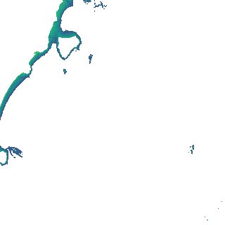
ga_s2ls_intertidal_cyear_3_x150y167_2019--P1Y_final.stac-item
dataset of product ga_s2ls_intertidal_cyear_3
Indexed by odc_admin
,
created
Region
x150y167
for
1st January 2019
Fields 🔗
creation_time
2024-04-02 01:25:07
dataset_maturity
final
eo_gsd
10.0
format
GeoTIFF
id
733bf598-5a17-4de5-8686-fc4cf578ff01
instrument
ETM_OLI_TIRS_MSI
intertidal_hat
1.17
intertidal_hot
0.84
intertidal_lat
-1.61
intertidal_lot
-1.52
intertidal_offset_high
11.64
intertidal_offset_low
3.27
intertidal_otr
2.36
intertidal_spread
85.09
intertidal_tr
2.78
intertidal_tr_class
mesotidal
label
•
lat
-14.737 to -14.436
lon
135.524 to 135.827
platform
landsat-7,landsat-8,sentinel-2a,sentinel-2b
product_family
intertidal
region_code
x150y167
time
2019-01-01 00:00:00 to 2019-12-31 23:59:59